Irrespective of which country you belong to, you are usually required to follow a few regulations governing drone flights. Once again, you have to follow these rules irrespective of whether you are flying a drone for recreational or commercial purposes. While some no-fly zones are easy to spot, some are not. For example, you are not legally allowed to fly your drones anywhere near airports, military bases and prisons. However, there are places such as national parks, where you are never sure whether it is legal and safe to fly a drone or not. This is the reason why we will be talking about a few apps that tell you where exactly you can fly your drones and where you cannot. Here is a look at them.
AirMap
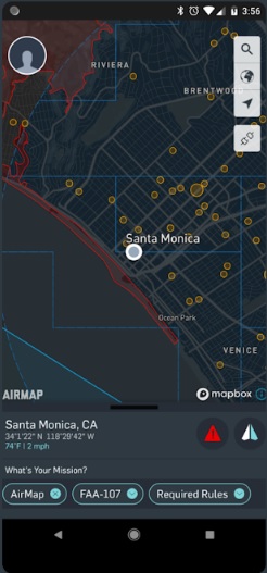
AirMap tops our list of the drone apps quite simply because of the fact that it offers comprehensive aeronautical data and services related to drones. There are several areas covered — i.e. situational awareness, traffic alerts and digital authorization. Users can actually access real-time feedback regarding the airspace regulations in relation to flight specifications. People from 20 countries (like the United States, Canada, Japan and Germany etc) can actually procure information regarding the national rule sets.
You can access very responsive vector maps in order to find out particularly about the airspace advisories and rules. Here is a quick look at all the important functions that you can actually end up performing here.
- Send over digital flight notices to the participating airports
- Create and manage your pilot profile
- Create and manage your UAV aircraft
- Obtaining traffic alerts on real-time for nearby manned aircraft
- Verify your flight plan based on the safety information you are getting
- Make changes in the plan, if required
KittyHawk
KittyHawk is another notable drone app (compliant with various devices), that actually allows you to perform several functions at the same time. With the detailed weather reports, you can devise a flight program, which is, at once compliant and reliable. The app offers several mobile and desktop tools that ensure that you’re flying safe. You have organized data to ensure that you’re navigating airspace, managing aviators and maintaining aircraft. The app has successfully met FAA requirements when it comes to operating rules, safe data exchange and airspace safety. The app assists you with the following activities:
- Log flight data
- Check airspace
- Weather
- Carry out safety assessments
- Real time UTM and aircraft telemetry
- Organize missions
- Sync data from DJI aircraft
- Take out LAANC authorization from the FAA
- Find out duly about compliance
- Obtain real time information about fleet operations so that you are not really encountering surprises
UAV Forecast App
If you want to track the no-flight zones accurately, then you can rely on another popular drone app, known as UAV Forecast app. It offers you detailed breakdown of the weather conditions and every little detail of the restricted zones. The weather details – notably- encompass cloud cover, wind speeds, visibility, chances of rain, precipitation, local temperature – and – of course- global information about flight restrictions. What more? You enjoy access to information about local flight regulations as well.
Best Drones Under 250 Grams – No FAA Registration Needed

